
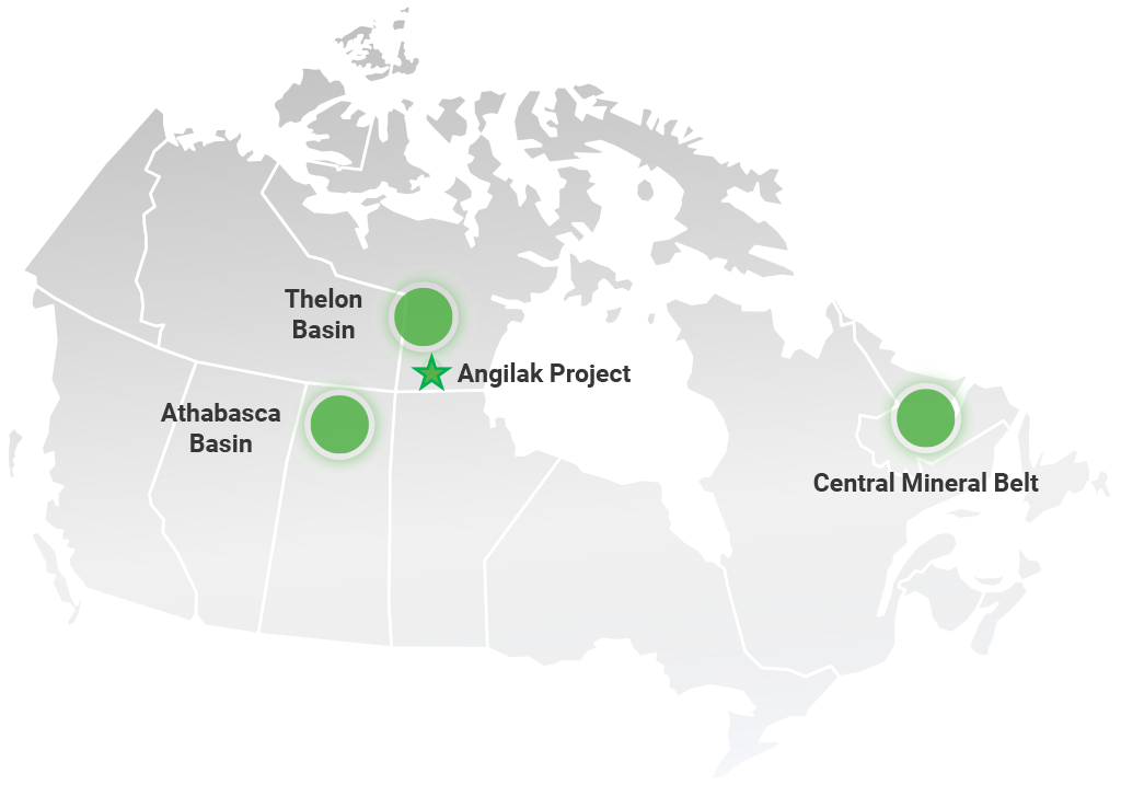
The Angilak Uranium Project
A high-grade uranium basin located in Nunavut with significant potential
An emerging basin, 100% owned by ATHA, with multiple uranium discoveries showcasing district scale
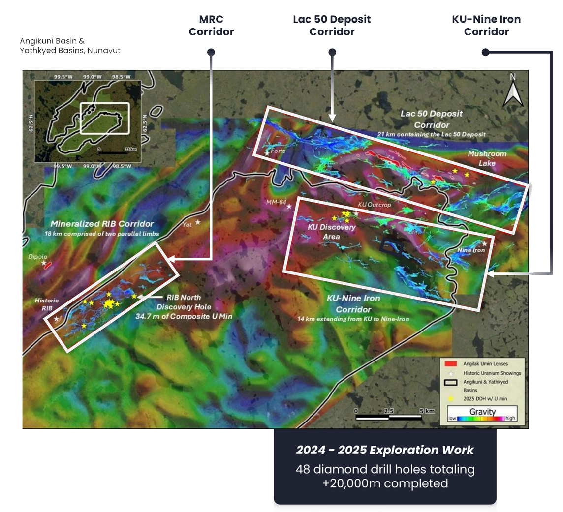
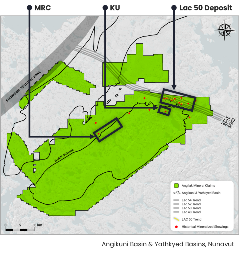
Lac 50 Deposit Corridor
21 km corridor hosting the Lac 50 Deposit, one of the largest high-grade uranium deposits in Canada outside the Athabasca Basin, remains open along strike and at depth with only ~24% of the corridor drill tested to date
MRC Corridor
18 km Mineralized RIB Corridor discovered during the 2025 program; four new discoveries (RIB North, East, West, South) identified across a 12 km strike with a 100% hit rate on all holes drilled
KU-Nine-Iron Corridor
14 km corridor extending from the KU Discovery to the Nine- Iron area within the Angikuni Basin; drilling intersected widespread uranium mineralization with grades up to 1.56% U3O8; 3D EM inversion identifying multiple untested targets along trend
The Lac 50 Deposit Corridor
Expanding the footprint of known uranium mineralization
The stated potential quantity and grade is conceptual in nature, and there has been insufficient exploration to define a mineral resource and it is uncertain if further exploration will result in the target being delineated as a mineral resource. The conceptual target for further exploration is based on available diamond drillhole data including the 2024 drill program results, and the ranges of potential quantity and grade were derived from conceptual vein wireframes, drill core assays, grade interpolation and applied uncertainty ranges.
Lac 50 Exploration Target Model
Conceptual Exploration Target
60.8M lbs – 98.2M lbs
Average Grade Range
0.37% – 0.48%
2024 – 2025
Exploration Work
The stated potential quantity and grade is conceptual in nature, and there has been insufficient exploration to define a mineral resource and it is uncertain if further exploration will result in the target being delineated as a mineral resource. The conceptual target for further exploration is based on available diamond drillhole data including the 2024 drill program results, and the ranges of potential
quantity and grade were derived from conceptual vein wireframes, drill core assays, grade interpolation and applied uncertainty ranges.
2025
- J4/Ray Zone expanded beyond the Exploration Target Model area — grades up to 1.47% U3O8
- Mushroom Lake drill-tested for the first time at depth, intersecting mineralization over 1 km strike length — grades up to 1.10% U3O8
2024
- 100% hit rate across all drill holes
- Expanded mineralization along Lac 50 Trend; identified three new parallel trends (Lac 48, 52, 54)
- Grades up to 5.85% U3O8
- Exploration Target established
The Company’s sole material property is the Angilak Project which is the subject of a technical report prepared in accordance with NI 43-101. The following technical disclosure relating to the Angilak Project has been extracted or summarized from the Angilak Technical Report, and is subject to all the assumptions, qualifications and procedures set out in the Angilak Technical Report. The following technical disclosure has been updated to include a summary of 2025 exploration activities and results. Readers should consult the Angilak Technical Report to obtain further particulars regarding the Angilak Project. The Angilak Technical Report is incorporated by reference in its entirety herein and is available for review electronically on SEDAR+ at www.sedarplus.ca under the Company’s corporate profile. Capitalized terms used in this summary but otherwise not defined, shall have the meanings given to them in the Angilak Technical Report.
Project Description and Location
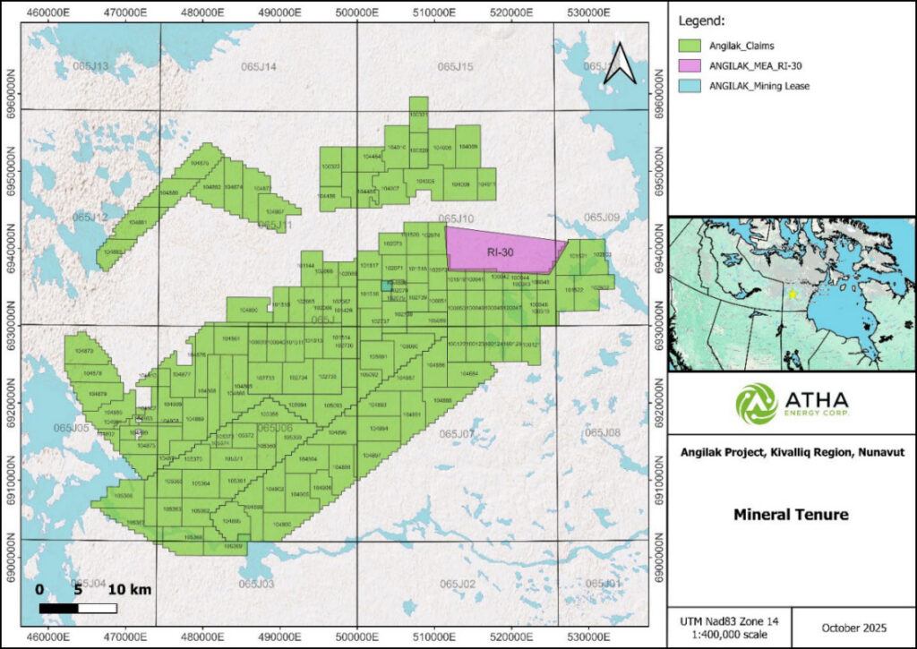
The Angilak Project, which hosts Lac 50 Deposit (as defined below), is located 350 km west of Kangiqliniq (Rankin Inlet) and 225 km southwest of Baker Lake in the Kivalliq Region of Nunavut. The Angilak Project is bound between Latitudes 62° 14’ and 62° 48’ North and Longitudes 98° 21’ and 99° 44’ West, (North American Datum 1983 (NAD83), Universal Transverse Mercator (UTM) Zone 14 coordinates: 6901449m N and 6960000m N and 463830m E to 533463m E) and is within the 1:50:000 National Topographic (NTS) map sheets 065 J/05, J/06, J/07, J/09, J/10, J/11, J/12, J/14 and J/15. The Angilak Project comprises 135 Crown issued mineral claims and one mining lease, as well as an Inuit Owned Land (“IOL”) parcel (RI30-001) for a total area of 201,760 hectares. Latitude Uranium, and subsequently the Company, has acquired the right to conduct exploration work on the IOL parcel under a Mineral Exploration Agreement (“MEA”) with Nunavut Tunngavik Inc. (“NTI”).
Land use permits enabling exploration work to be conducted on the Angilak Project have been issued, amended and renewed by the Kivalliq Inuit Association (“KIA”) for parts of the Angilak Project covering the IOL and by Crown-Indigenous Relations and Northern Affairs Canada (“CIRNAC”) for the Crown Lands. Figure 1 depicts the general location of the Angilak Project as of the effective date of the Angilak Technical Report.
Figure 1: Angilak Project Land Tenure
Access
Access to the Angilak Project is reliant on helicopters and fixed wing aircrafts. There is a gravel airstrip located at the Nutaaq drilling camp and a secondary airstrip 1.5 km west of the Nutaaq drill camp. Exploration at the Angilak Project is typically conducted between the months of February and October. Local access to and around the Angilak Project site is by either helicopter, float plane or wheeled fixed wing aircraft such as a Single Otter. Commercial-grade airports in Baker Lake and Rankin Inlet are used as mobilization points for supplies and people. Required infrastructure for exploration can be brought in each field season with a Single Otter typically available in Baker Lake.
Land Tenure
Under the Nunavut Mining Regulations (“NMR”), the duration of a recorded mineral claim is 30 years, beginning on its recording date, plus any extensions, unless the recorded claim is taken to lease or cancelled. In order to keep a mineral claim in good standing, a holder of a recorded claim must do work that incurs a cost annually beginning on the day on which the claim is recorded for each unit (approximately 18 to 19 ha) included in the recorded claim as follows:
- $45 in respect of the first year;
- $90 in respect of the second to fourth years;
- $135 in respect of the fifth to seventh years;
- $180 in respect of the eighth to tenth years;
- $225 in respect of each of the eleventh to twentieth years; and
- $270 in respect of each of the twenty-first to thirtieth years.
To maintain the mineral claim in good standing a report of work (assessment report) is required to be filed within 120 days after the second anniversary of the recording of the claims or any subsequent anniversary date. Work reported in one report must have been performed within a period of not more than 12 consecutive months during the four years immediately preceding the day on which the report was submitted and after the day on which the claim was recorded. Expenditure costs are required to be filed with the assessment report along with a table setting out the cost of work (expenditure) that is allocated to each claim. The Mining Recorder will evaluate the assessment report to assess their compliance with NMR and determine the cost of work to be set out in a certificate of work. Once the expenditures are approved an allocation of work can be completed on the Nunavut Map Selection (NMS) and will result in the updating of expiry dates of the claims. An assessment report for the 2023 and 2024 field programs covering all the claims (including those with expiry dates in 2023) comprising the Angilak Project was filed in December 2023 and 2024 (the “2023 and 2024 Assessment Reports“). The 2023 and 2024 Assessment Reports and expenditures have been reviewed and approved by the Nunavut Mine Recorders Office. Assessment credits related to 2023 and 2024 exploration expenditures will be allocated the mineral claims extending expiry dates and maintaining the mineral tenements in good standing for an additional 6 to 10 years.
At any time during the life of the mineral claim, the holder may apply to convert all or a portion of the mineral claim to a mining lease, as long as a certificate of work has been issued in respect of the claim that allocates to the claim a total cost of work of at least $1,260 per unit. No exploration work is required once the application to convert the mineral claim to a lease is filed with the mining recorder. The application to convert a mineral claim to a mining lease must be accompanied by a legal survey. No exploration is required for granted mining leases. A mining lease is normally granted for a term of 21 years and is renewable for further terms. Mining of any mineral product may only be conducted on a mining lease.
The holder of the mining lease that was issued before November 1, 2020, is required to pay an annual rental fee of $2.50 per hectare during the first term and $5.00 per hectare during each renewed term before that date. The annual rent for a lease that is issued on or after November 1, 2020, and for any lease that is renewed on or after that date is $10 per hectare.
Work and fees for IOL Parcel RI30-001 are described in the MEA between the Company and NTI, and are as follows:
Annual fees:
- $1.00 per hectare in respect of the first year;
- $2.00 per hectare in respect of the second to fifth years;
- $2.50 per hectare in respect of the sixth to tenth years; and
- $4.00 per hectare in respect of the eleventh to twentieth years.
Exploration Work:
- $4.00 per hectare in respect of the first and second years;
- $10.00 per hectare in respect of the third to fifth years;
- $18.00 per hectare in respect of the sixth to tenth years;
- $30.00 per hectare in respect of the eleventh to fifteenth years; and
- $40.00 per hectare in respect of the sixteenth to twentieth years.
Drilling
Drilling has been conducted on the Angilak Project by several previous exploration companies prior to the Company acquiring the claims in 2024. Essex Minerals, Urangesellschaft, Noranda Exploration and Pan Ocean conducted diamond drilling during the early exploration period from the 1970s to 1982, and Western Mining Corporation in 1994-1995. Kivalliq Energy conducted consistent exploration between 2008 and 2018 with diamond drilling in 2009, 2010, 2011, 2013 and 2015 (total 78,835 metres), and RC drilling in 2011 and 2012 (total 11,684 metres), further delineating the Lac 50 Deposit in 2013 and discovery of new mineralized zones or extensions of existing zones. ValOre completed a twenty-six hole, 3,590 metre diamond drillhole program and a twenty-seven hole, 3,165 metre RC program in 2022 focusing on Dipole, J4 West and Yat zones. Latitude Uranium completed a diamond drill program in the Lac 50 Deposit area specifically targeting the Main Zone. The 2023 drill program successfully increased the extent of known mineralization and identified new mineralization horizons. A total of 18 diamond drillholes totalling 5,662 metres were completed.
2024 Drilling Summary
The Company conducted a 10,052-metre helicopter-supported diamond drill program between June 4 and August 22, 2024. A total of twenty-five drillholes were completed, not including one lost drillhole. This drilling program had several key objectives: to expand the footprint of known mineralized zones within the Lac 50 Trend (Western Extension, Eastern Extension, Main Zone, J4, and Ray zones) by testing along strike, down-dip, and down-plunge. Additionally, it aimed to investigate historical data by testing previously identified VLF anomalies and mineralized showings in under-drilled areas identified as the Lac 48, Lac 52 and Lac 54 Trends (which include the Blaze, Hot, Pulse, and Mushroom Lake zones). Certain significant results of the drilling program are summarized below.
Main Zone Drilling
The Lac 50 Main Zone mineralization is structurally and stratigraphically controlled within a sulphidic-chloritic-graphitic tuffaceous metasediment and/or volcaniclastic interlayered within Archean basement metavolcanics, of which the protoliths are typically massive basalt, pillowed basalt and subvolcanic gabbro. These lithostructural characteristics are typical of all deposits and showings in the Lac 50 area. The objective was to evaluate along strike and downdip and expand the footprint of mineralization in the Main Zone area. Three drillholes were completed in this area, for a total of 1,444.8 metres. Drilling results show narrow intercepts of veined and tuff-associated mineralization extending into the hanging wall and along strike of areas tested in the Main Zone.
Blaze Zone
Within the Blaze Zone, mineralization is associated with faults and breccia zones where the dominant northwest mineralization trend is cross-cut by a north-east trending structure. This may be the cause of significant normal faulting and large damage zone around mineralization. One drillhole tested the continuity of the mineralization at depth. Two zones of mineralization were intersected with grades of 0.37% U3O8 over 2.0 metres from 94.0 metres, including 0.99% U3O8 over 0.5 metres from 94.5 metres and 0.17% U3O8 over 0.5 metres from 164.0 metres. These intersections were identified as an extension of the main Blaze Zone. The mineralization is hosted within a quartz-carbonate-hematite breccia in the basalt host rock.
Eastern Extension
The Eastern Extension has similar geological characteristics and mineralization controls to the Main Zone. Mineralization is associated with structural disruption concentrated along tuff horizons cross-cut by more discrete north-east trending faults with associated quartz-carbonate veining and uranium mineralization. The objective of the 2024 drilling was to test the down-dip extension of mineralization at depth outside of the historical mineralized footprint. Two drillholes, EEX-DD-052 and EEX-DD-053 for a total of 787.3 metres, targeted down-dip of historical drilling EEX-DD-023 to EEX-DD-030. These drillholes exhibit grade intervals up to 2.66% U3O8 over 1.75 metres from 190.7 to 192.4 metres in EEX-DD-026 and 4.34% U3O8 over 0.72 metres from 88.8 to 89.5 metres in EEX-DD-030. EEX-DD-052 intercepted mineralization with 0.25% U3O8 over 0.5 metres in a quartz-carbonate-hematite vein at 346 metres. This occurred within a damage zone approaching the brecciated tuff horizon intersected from 365.6 to 366.1 metres. Another mineralized interval was intersected below the tuff unit within a quartz-carbonate-hematite veining with 0.1% U3O8 over 1.1 metres. EEX-DD-053 targeted approximately 110 metres to the southeast and at depth, along strike of the general mineralized trend. Mineralization was intercepted with 0.36% U3O8 and 0.27% Cu over 0.5 metres at 111.2 metres associated with a brecciated, hematized quartz-carbonate vein. Additionally, 0.04% U3O8 over 1.1 metres was intercepted at 305.3 metres. This mineralization is associated with bleached veins and shears within the tuff unit intersected between 304.6 and 307.9 metres. Overall, mineralization was successfully extended at depth within the Eastern Extension and remains open in all directions.
Western Extension
One drillhole was completed in the Western Extension and was designed to test for potential mineralized structures within the footwall of the Western Extension. WEX-DD-079 was drilled to 334.8 metres and intersected mineralization with 0.04% U3O8 over 1.7 metres from 39.8 metres, and 0.04% U3O8 over 0.5 metres from 60.6 metres.
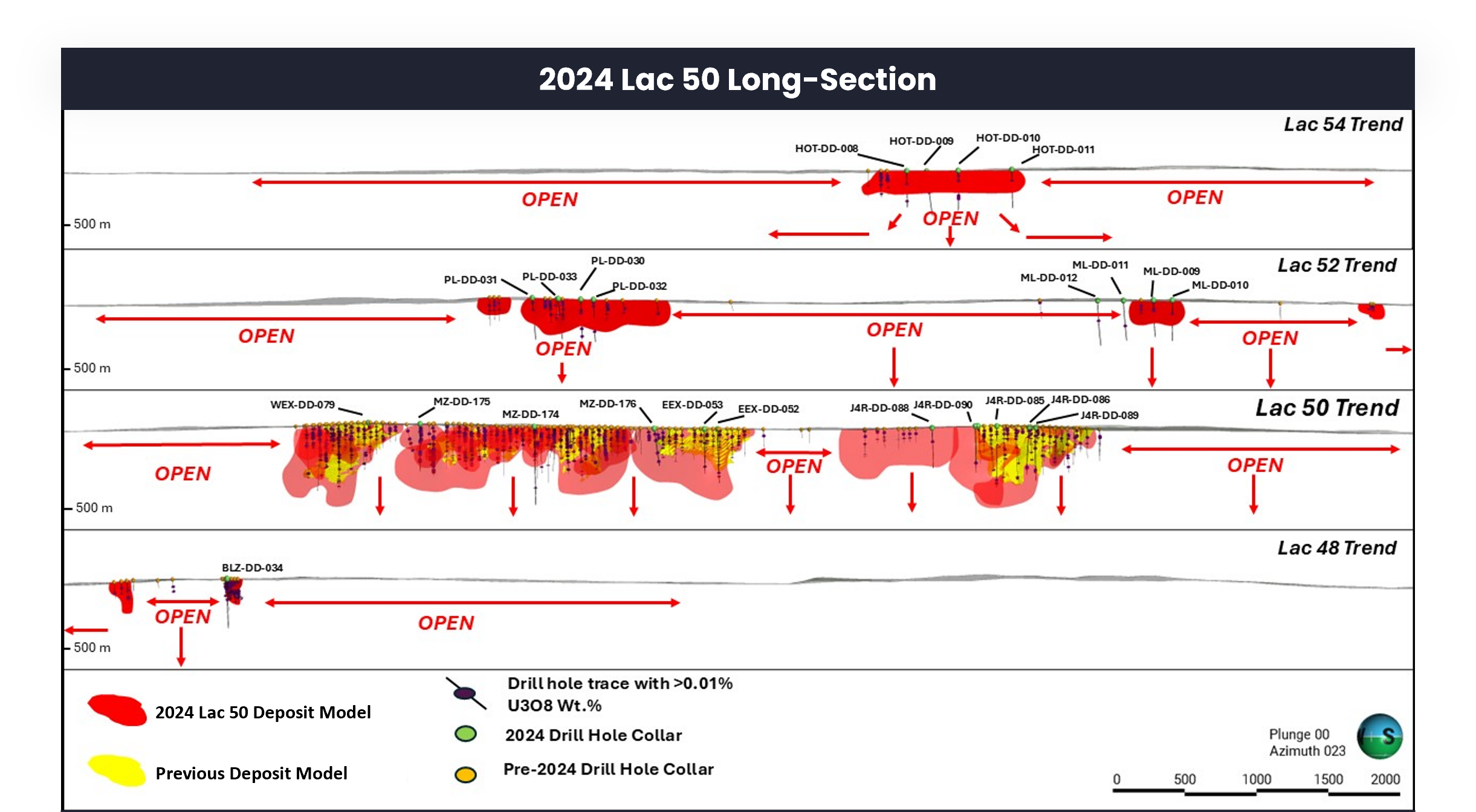
The Lac 50 Deposit contains multiple parallel trends
that are open to be tested in all directions and at depth
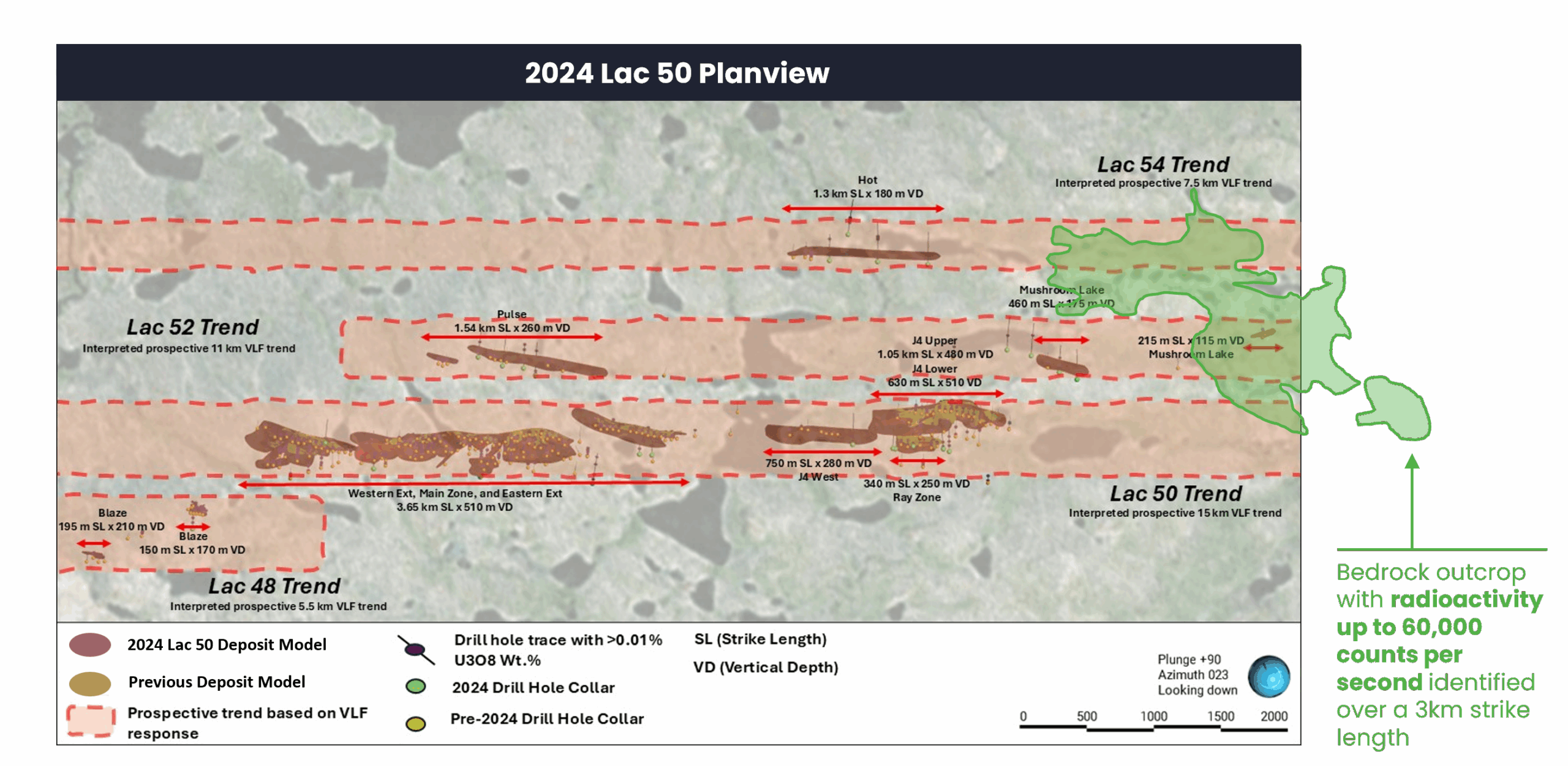
2024 Lac 50 Deposit Long-section Schematic
2025 Drilling Summary
In 2025, ATHA completed its second exploration campaign on the Angilak Project which was focused on continued expansion of the Lac 50 deposit mineralization footprint at the J4/Ray Zone, testing the down-dip continuity of mineralization identified on surface at the Mushroom Lake zone, and testing of high-priority regional targets within the KU and RIB areas located within the prospective RIB-Nine Iron corridor. As part of the 2025 campaign, a total of twenty-two diamond drill holes for a total 10,774-metres of drilling was completed.
In the Lac 50 deposit area a total of three drill holes and 1,608 metres were completed at the J4/Ray and Mushroom Lake zones. At the J4/Ray zone, drilling successfully extended mineralization down-dip by approximately 100 metres and remains open both along strike and at depth. At Mushroom Lake, two drill holes were completed to test the depth extent of uranium mineralization identified in outcrop. Both drill holes successfully intersected uranium mineralization as identified by preliminary down-hole radiometric probe results and remain open at depth and along strike. Down-hole radiometric probe results were obtained using a Mount Sopris 40TGU-1000 Triple Gamma Geiger probe.
Final geochemical analytical results for the 2025 Lac 50 and KU drill core samples were received in late 2025. Final drill core sample assays for the Lac 50 and KU drill holes were publicly disclosed in a news release dated February 26, 2026. Drilling results in the KU area are highlighted by drill hole KU-DD-001 which intersected total composite mineralization of 15.1m, from 85.0 m down to a depth of 502.6m, including a shallow interval of uranium mineralization from 85.5 m to 86.0m with a grade of 1.56% U3O8. In the Lac 50 area, drilling results are highlighted by drill hole ML-DD-014 (Mushroom Lake) which intersected total composite mineralization of 2.5m, from 335.3 m to 364.2 m, including 1.10% U3O8 from 363.7 m to 364.2m. Along the J4/Ray Zone of the Lac 50 Trend, one drill hole was completed which intersected total composite mineralization of 5.6 m from 42.4 m to a depth of 570.2m, including 1.47% U3O8 from 206.6 to 207.1 m.
At the RIB regional target area, a total of thirteen drill holes and 5,739 metres were completed to test stacked gravity and EM anomalies coincident with interpreted NE-SW, E-W and N-S trending structures along the regional RIB-Nine-Iron corridor. All drill holes successfully intersected mineralized structures associated with graphitic shears zones over an interpreted 12-kilometre conductive EM trend within the RIB area, with the most significant intersection coming from the RIB North area in drill hole RIBN-DD-001 which intersected 34.7m of total composite uranium mineralization within seven zones from 287.0 to 439.9m. The widest continuous intersection was encountered at a down-hole depth from 426.3 m to 439.9m, returning 13.6m of composite uranium mineralization grading 0.53% U3O8, including 1.1m grading 4.81% U3O8 with the highest-grade sample returning 8.16% U3O8 over 0.5 m.
Composite mineralization is calculated using 0.01% U3O8 cutoff with a maximum internal dilution of 1.5m. The Company considers high-grade mineralization to be any interval over 1% U3O8. Drill intercepts are core width and true thickness is yet to be determined.
Sampling, Analysis and Data Verification
Sample Preparation
Core samples collected during the Company’s 2024 and 2025 diamond drilling program include; 1) half-split NQ drill core for assay samples, 2) 10-metre composite samples comprised of 1 to 2 centimetre discs of core taken from the bottom of each row in the core box over 10-metre intervals, and 3) 10 centimetre core lengths for density samples. All core was logged, sampled, and stored at the Nutaaq Camp logging facilities. Splitting areas at the camp were thoroughly cleaned of dust and rock chips between samples to prevent cross-contamination during the splitting process. The samples were placed in sample bags and sealed in plastic or metal pails, depending on the radioactivity level. All samples were flown to Baker Lake, then transported by cargo planes to Winnipeg before being road transported to the SRC. Sample shipments were accompanied by Transport of Dangerous Goods (“TDG”) documentation completed by qualified personnel. A request for analysis form was prepared prior to shipment, detailing each batch of samples, sample types, preparation codes, and analysis codes. All samples for assay, density, or geochemical analysis for the drilling campaigns were submitted to the SRC Laboratory in Saskatoon, Saskatchewan. There were no significant issues identified concerning sample shipments or sample security during 2024 and 2025 drilling programs.
Security
In 2024 and 2025, as each hole was drilled, drilling contractor personnel placed the core in boxes at the drill site and secured core boxes with lids screwed on, tied, or nailed to the box. Core was then delivered to the core processing facility via helicopter daily, twice a day, or when weather conditions permit. All core was logged, sampled and stored at the Nutaaq Camp logging facilities. On site sample preparation consists of core splitting by geological technicians under the supervision of geologists. One half of the core is placed in sample bags with a sample number tag and the other half is returned to the core box, which is later stored at the core storage area located near the logging facility. The bags containing the split samples are then placed in buckets with lids for transport. All samples were flown to Baker Lake, then transported by cargo planes to Winnipeg, before being road transported to SRC. The samples were accompanied by TDG documentation completed by qualified personnel. A request for analysis form was prepared prior to shipment, detailing each batch of samples, sample types, preparation codes, and analysis codes. Samples were received at SRC either as dangerous goods requiring appropriate TDG documentation or as exclusive-use samples (with no radioactivity documentation attached). Upon arrival, all information pertaining to a received shipment of samples is verified by sample receiving personnel, including sample numbers, number of pails, sample type/matrix, condition of samples, and request for analysis. After the completion of analyses, data are sent securely via electronic transmission to the Company. These results are provided as a series of PDFs and an Excel spreadsheet. SRC places a large emphasis on confidentiality and data security. Appropriate steps are taken to protect the integrity of samples at all processing stages. Access to the SRC premises is restricted and monitored. SRC is an ISO/IEC 17025/2005 and Standards Council of Canada certified analytical laboratory and is independent of the Author and the issuers.
Quality Assurance / Quality Control
Standard Operating Procedures ensure consistency and quality control in the selection and preparation of core samples, safeguarding data integrity at the Angilak Project. The sampling procedures define the frequency at which control samples are inserted into the core sample stream by the Company’s personnel. Control samples include blanks, standards, and duplicates. Duplicate samples are split from half-split core using a hydraulic splitter. Blanks and standards are certified reference materials (“CRM”). The Company purchased CRMs for insertion into the sample stream from OREAS North America, located in Sudbury, Ontario, Canada. Five certified uranium CRMs were used: OREAS 120, OREAS 121, OREAS 122, OREAS 123, and OREAS 124. The performance of these standards was evaluated based on the criterion that assay results fall within three standard deviations of the certified value, as reported by the manufacturer. For CRMs where total digestion techniques (i.e. 4-acid digestion) used for certified values vary from SRC’s total digestion technique (i.e. 3-acid digestion), CRM mean and standard deviations have been determined directly from SRC analytical results and used for quality control purposes typically resulting in more stringent control criteria. Additionally, three certified blank CRMs were used: OREAS coarse sand (silica), OREAS 22h, and OREAS 90. Latitude Uranium and the Company utilized a range of standard reference materials sourced from OREAS to ensure the quality and accuracy of analytical results. As the SRC laboratory does not provide certified values for its analytical methods in conjunction with these standards, in-house certified values are being established. Field control limits were calculated from the 2023 and 2024 assay results and applied retroactively; any significant deviations from the expected values are promptly flagged and addressed. Of the 391 standards measured in 2023-2024, only three standards fall outside of the acceptable range of mean plus three standard deviations (SD). Two of the standards are related to OREAS 121 and one is related to OREAS 120, which are both low grade standards. The Company considers these results acceptable. The Company has communicated that re-analysis will be completed on the failed standards. Of the 193 blanks measured in 2023-2024 no samples fall outside of the accepted range.
Data Verification
The Company’s personnel completed an internal audit of the Angilak Project drillhole database by comparing approximately 10% of the drilling data to the original drill logs, assay certificates, and collar coordinates. Original assay certificates and geological logs were used to check the MXDepositTM database after import from previous drilling. Minor typos and column mismatches were found and rectified, but overall, the drillhole database was found to be satisfactory. However, the RC drilling assay results were deemed to be imprecise relative to the validated core drilling results, and thus the RC drilling was not considered in the exploration target model. The QP reviewed the audit work completed by the Company and considers the results, methods, and conclusions to be accurate and appropriate. The QP further validated the diamond drilling database via the following digital queries: • Header table: searched for incorrect or duplicate collar coordinates and duplicate hole IDs. • Survey table: searched for duplicate entries, survey points past the specified maximum depth in the collar table, and abnormal dips and azimuths. • Lithology, alteration, and structure tables: searched for duplicate entries, intervals past the specified maximum depth in the collar table, overlapping intervals, negative lengths, missing collar data, missing intervals, and incorrect logging codes. • Geochemical, density, and assay tables: searched for duplicate entries, sample intervals past the specified maximum depth, negative lengths, overlapping intervals, sampling lengths exceeding tolerance levels, missing collar data, missing intervals, and duplicated sample IDs. No significant issues were identified. During the QP’s two-day site visit, he reviewed ongoing, recent, and historic core from the Deposit, confirmed the location of three collar locations with a handheld GPS, verified the geological setting, and reviewed drilling, logging, sampling, analytical and QA/QC procedures. A comparison of the drill logs and assay results with the laid-out drill core showed that the information recorded in the drill database matched well with the drill core. As part of the core review, the QP verified the occurrences of mineralization visually and by way of a hand-held scintillometer.
Mineral Processing and Metallurgical Testing
In June 2012, the SRC commenced a metallurgical testing program that built on first pass work completed in 2010. The initial 2010 results indicated alkaline leaching as the most effective extraction process for the Lac 50 Deposit uranium mineralization. The objective of the 2012 program was to investigate uranium alkaline leaching optimization and perform a preliminary evaluation of the purity levels of a final yellowcake product. The SRC aggregated a master composite sample weighing approximately 60 kilograms by blending and homogenizing 166 quarter-split and half-split pulp reject samples from 51 core holes. The sampled 2010 and 2011 core holes represent 3.2 km of strike length of uranium mineralization along the Lac 50 Main Zone, Western Extension and Eastern Extension. A head grade sample from the 2012 composite assayed 0.737 % U, 0.217% Mo, 0.667% Cu, 0.221% Zn, 0.231% Pb and 26.7 g/t Ag. Optimized results from alkaline leaching indicate that 94.1% of uranium can be extracted in 48 hours and 95.9% of the uranium extracted in 72 hours with a final yellowcake product that contained 71.9% uranium. It is encouraging at this early stage that the assayed impurities in the yellowcake product are below the maximum allowable concentration limits without penalty for uranium ore concentrate specifications. Additional metallurgical work is warranted.
Mineral Resource and Mineral Reserve Estimates
There are no current Mineral Resource and Mineral Reserve Estimates for the Angilak Project.
1HISTORICAL DRILLING AND OUTCROP SAMPLES
For additional information regarding ATHA’s Angilak project please refer to the Technical Report entitled “Technical Report on the Angilak Property, Nunavut, Canada” with an effective date of October 14, 2025 prepared by Matt Batty, MSc, P. Geo, who is a “qualified person” under NI 43-101, available under ATHA’s SEDAR+ profile at www.sedarplus.ca.
DOWNHOLE GAMMA PROBE
A Mount Sopris 40TGU-1000 Triple Gamma Geiger down hole probe was utilized for radiometric surveying.
The Company considers high-grade mineralization to be any interval with radioactivity derived from downhole gamma probe >10,000 CPS. The total gamma results provided were selected using an average cutoff of 500 CPS over intervals of 0.1 metre width. All drill intercepts are core width and true thickness is yet to be determined. Core samples are submitted to the Saskatchewan Research Council (SRC) Geoanalytical Laboratories in Saskatoon. The SRC facility is ISO/IEC 17025:2005 accredited by the Standards Council of Canada (scope of accreditation #537). The samples are analyzed for a multi-element suite using partial and total digestion inductively coupled plasma methods, for boron by Na2O2 fusion, and for uranium by fluorimetry.
Sign Up for Updates from ATHA Energy Corp
Sign up to receive the latest ATHA Energy Corp. updates directly to your inbox.